
By Jen
I have returned, hale and hearty, from my epic adventure to Lake Maria State Park. I ultimately packed pretty much exactly what I said I would–I can’t remember including anything else. So, how did it go?
In short, it was awesome! Mostly sunny, I think a high of about 25 F. We didn’t get a lot of wind, which was nice. As you can imagine, a lot of roads headed out into rural Minnesota don’t have a lot of wind protection.
The overall plan was to take the Northstar Commuter Rail Line from Minneapolis (the Target Field Station) to Big Lake, MN and bike from there to Lake Maria State Park. Then we went hiking and reversed the procedure for the trip home.
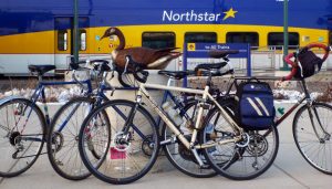
Our bikes (and a loon sculpture) before boarding the train for our trip home.
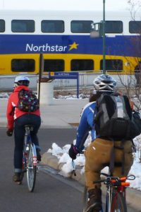
There are only three trips each way on the Northstar on Saturdays and Sundays. The earliest one leaves Minneapolis at approximately 11:30 and the last one leaves Big Lake at 5:13. That gave us just under five hours before we had to catch the train back. The great thing about being at the last stop was that the nice warm train was waiting at the station when we arrived, so we didn’t have to stand around outside in the cold. Northstar fares are based on day of travel and distance. It’s $5.25 each way for weekend travel to Big Lake (the U-pass or College To-Go card doesn’t cover the whole fare, so if you have one of those, be prepared to pay the difference).
Here’s a link to the map of the route we took, a distance of about 13 miles each way, which took about an hour. We chose to ride the smaller neighborhood roads between the train station and Lake Street and were flexible about how we did that, so this map only approximates those directions. Most of the major roads had wide shoulders, approximately the width of an entire lane. Those that didn’t had two lanes of traffic in each direction, so our group of four alternately rode single file farther into the lane and rode in pairs side-by-side to take the lane entirely. There were a few drivers who found it necessary to change lanes entirely (good-everyone was great about giving us plenty of space) and then zoom past us at ridiculous speeds (bad, but at least they were in the other lane). On the other hand, when we were stopped at a light on our way back, one driver rolled down her car window to tell us she thought we were awesome. 🙂
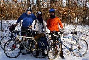
Three fourths of the people, all of the bikes. I’m the one in the goggles–this is how I normally start out my rides below 30 F.
At this time of year and with this level of snow coverage, there aren’t a whole lot of people out in the park (cross-country skiing conditions weren’t very good and there was really no point in using snowshoes). The park office was closed, so all park entry fees ($5/car, free otherwise) and camping reservations were self-service. There’s a heated trailhead building near the parking lot, which has running water, bathrooms, indoor and outdoor picnic tables, a few interpretive signboards, and a wood-burning stove. We stopped there for a leisurely (indoor) picnic lunch and spread any cold or damp belongings out near the stove to dry.
My toes got too cold on the ride over, so I changed my socks and duct-taped handwarmers to the outside of the toes before we geared up to go back outside. I pretty quickly got sweaty feet, but they were warm the whole rest of the trip. Outdoors in the winter, too much sweat = bad, but my feet seem to have two settings: cold and sweaty (or cold and no-blood-in-my-toes and sweaty) or warm and sweaty. Warm and sweaty is by far preferable. (Hey, this is the Grease Rag blog. We tell it like it is.)
After lunch, we went hiking! Had there been more snow, we would have brought snowshoes. (Thanks to Lowrah for telling me about strapping snowshoes to your bike…last year, when we had snow.) We tramped around for about 90 minutes, a tour that took us through the trees, along a small patch of hillocks of snowed-under prairie grass, and to the edge of Bjorkland Lake, where a snow angel was made.
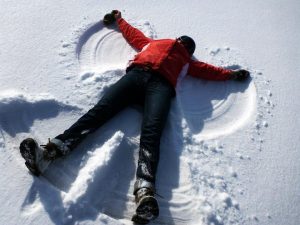
Making a snow angel.
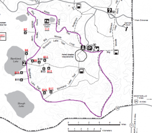
Here’s a section from the state park map. Our hiking (maybe) route is outlined in purple. I’m still working on map reading skills while hiking, so our more experienced navigators lead the way, but I think this is where we went.
Then it was back to the trailhead building to eat a snack and gear up for our ride back to the train.
Other logistic notes:
–We all wore heavy winter boots/hiking boots, not bike shoes. We each decided that was preferable to hiking in bike shoes or carrying a change of shoes. Other factors of that decision: not owning specialized biking shoes or not owning shoes designed for weather that cold.
–We locked our bikes to an unused ski rack outside the trail center (and to each other). I brought a mini U-lock and cable, because with just the small lock I don’t have a lot of flexibility with what I lock to. I think everyone else had regular-sized U-locks. I strapped my lock to my bike rack so I wouldn’t have to carry it on my back while riding.
We revisited this activity with a tromp around Minnehaha Falls this weekend, meeting up by bike but not riding much together. We didn’t take the train this time, but the LRT is a good option to shorten the trip for someone who lives in N/NE/SE Minneapolis.